

The Road Built for Tea: A Silk Route Story from Zuluk to Nathula

I've spent most of my adult life driving old trade roads, and I think it goes back to my first life as an architect — I've never been able to look at a road or a border post without asking who built it, and why there, and why like that. A mountain doesn't hand you a route. Someone surveys it, argues over it, sometimes bleeds for it, and only much later does it become the pretty thing you photograph from a car window. That curiosity is what took me across the Pashmina Route — Manali, over into Zanskar, down through Kargil, into Kashmir — chasing the wool that once moved by mule along that corridor. This time I've come further east, to a smaller, steeper, far less talked-about stretch of the same old trading world that once connected India to Central Asia: the road climbing out of the Bengal plains toward Tibet, through a sleepy army village called Zuluk and up to a heavily guarded, breathtakingly cold border called Nathula.
Almost every guest who comes to Sikkim ends up standing at one or both of these places. Almost none of them know what they're actually standing on. I want to tell you.
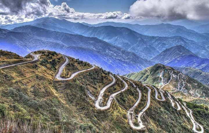
32 loops of Dzuluk, Sikkim
Zuluk: The Road That Comes Before the Reveal
You'll see Zuluk before you understand it — that's usually how it goes. It shows up on a screen first: a ribbon of road folding back on itself again and again up a hillside, somewhere around thirty-two hairpin bends (the count shifts depending on where you start), climbing roughly 1,500 feet in a few dizzying minutes. It's become one of the most photographed roads in the Eastern Himalaya, and almost everyone who takes that photo assumes it's simply spectacular scenery with a good camera angle.
Here's the part that changes the picture. That road wasn't built for the view. It's a Border Roads Organisation road, built mostly to move army supplies and troops up to the frontier, and Zuluk today still functions as a military transit camp — a place to pause and acclimatise before pushing higher. But it didn't invent this corridor. It's laid along the bones of a much older road: a mule track mercantile Sikkim had already been using for close to three hundred years before anyone paved it. Near Thambi View Point, short stretches of the original stone-paved trail are still there, sitting quietly beside the tarmac that replaced it.
From roughly the seventeenth century onward, this belt of East Sikkim carried caravans between Lhasa and the Bengal plains near Kalimpong, using a pass called Jelep La as the main crossing — Nathula, further north, was the parallel, slightly longer alternate route. Traders came down out of Tibet with raw wool, musk, yak tails and precious stones, and went back up carrying raw silk, spices, tobacco and textiles a high, isolated plateau simply couldn't produce for itself. Rhenock, close to Zuluk, was the first halting station on the route out of Kalimpong, where mule trains rested and resupplied at its old Haat Bazar. Aritar, further along, got Sikkim's first police outpost in 1897 — not for crime, but because a trade route moving this much value needed managing. Zuluk's zigzag road is the modern descendant of a working supply chain, not a scenic invention dressed up as one.

The Deal That Built Nathula
By 1873, British surveyor J.W. Edgar was already documenting brisk trade through these passes, carried by Tibetan merchants who needed no convincing this route worked. The 1861 Treaty of Tumlong had brought Sikkim under British protection, and a first attempt at formalising borders and trade terms — the 1890 Convention — fell apart because Tibet itself hadn't been party to it.
Britain tried again in 1893, and this time the deal was built around something very specific: tea. On 5 December that year, Trade Regulations signed in Darjeeling opened a formal trade mart at Yatung, just over the pass in Tibet's Chumbi Valley. China agreed to let Indian tea into Tibet at a duty no higher than what Chinese tea paid entering England — a calculated move to break into a market of an estimated three million tea-drinkers, using a commodity light enough for a mule to carry over a 4,000-metre pass. Worth saying clearly: this isn't the same road as China's famous Yunnan–Sichuan Tea Horse Road, a separate network — but Yatung, the post this corridor fed, is still described by Chinese sources as effectively the last stop of that wider tea-trading world reaching in from the east. So this genuinely was an old tea trade route to Tibet, built on purpose, decades before anyone crossed it for a photograph.
Trade only grew from there. Francis Younghusband's 1903–04 mission to Lhasa used Nathula and Jelep La as its main supply lines, and German explorer Ernst Schäfer's expedition crossed legally in 1938–39. Jawaharlal Nehru formally opened the motorable Gangtok–Nathula road on 17 September 1958, and by the 1950s the pass was doing serious business: caravans of roughly two hundred mules, each carrying about 80 kilograms, took twenty to twenty-five days to cross. Medicines, fuel and even disassembled cars went north into Tibet; wool and silk came south. Nearly 95% of the authorised trading firms working this route were run by the Marwari trading community — a detail that always makes me smile, because it means one of India's great trading communities was doing brisk business at 14,000 feet long before anyone called it "experiential travel."

Nathula Closes - 1962
The 1962 Sino-Indian War ended all of it overnight. The border sealed shut, and a working trade post turned, almost instantly, into a tense military line.
Five years later, it turned violent. From 7 September 1967, Chinese troops began digging in on ground India considered its own; when Indian engineers laid wire on 11 September to mark the boundary, a scuffle escalated into machine-gun and then artillery fire lasting three days and nights. India's Ministry of Defence recorded 88 killed and 163 wounded on its side; China claimed 32 of its own soldiers lost, and both countries' figures about the other side's losses remain disputed. A related clash followed at nearby Cho La on 1 October. India held the stronger ground at both, and the border then stayed quiet for the next 53 years.
The politics took even longer to settle than the guns did. Sikkim became an Indian state in 1975 after a referendum China didn't initially recognise. It took until 2003 for China to indirectly accept Sikkim as Indian territory, and in 2005, Chinese Premier Wen Jiabao said publicly that "Sikkim is no longer the problem between China and India." That quiet thaw is the only reason any of us can stand at Nathula today.

The Gate Reopens - 2006
Nathula reopened for limited border trade on 6 July 2006, forty-four years after it sealed — a ceremony that saw a hundred traders from each side cross through a new stone-walled passageway that replaced the old barbed wire. And here's the twist nobody expects: trade never came close to matching the hype. A 2005 study projected it would reach roughly ₹353 crore by 2010; what actually crossed between 2006 and 2010 was ₹6.54 crore, under 2% of the estimate. By 2015 it had grown to ₹114.6 crore — still only about a quarter of the original, more modest projection.
What actually took off wasn't trade. It was tourism. Nathula is one of the very few places in this country where an ordinary civilian can stand at a live, guarded international border and watch soldiers of another country going about their day. Indian citizens and OCI cardholders can apply for a permit in Gangtok, capped at 200 vehicles a day, confirmed only the morning of travel and non-refundable if weather shuts the pass. Tourists can only visit four days a week, and only before around 9 AM — which, combined with Nathula sitting roughly two and a half hours from Gangtok, is the entire reason almost every guest's first full day in Sikkim looks the same: Nathula first, then New Baba Mandir — a shrine to a soldier, Harbhajan Singh, venerated as a guardian spirit of this border — and Tsomgo Lake on the way down. It has quietly become the default itinerary of an entire state, built around the opening hours of a border post most visitors assume is purely ceremonial.
The Mail Game - Why Nathula remians closed 2 day a week
There's one detail from all of this I keep coming back to, because it's the quietest and, to me, the most moving. Twice a week — Thursdays and Sundays, at 8:30 in the morning — a small ceremony still takes place at Nathula: an exchange of international mail across the border, a tradition going back to the days of the Chogyal that has continued, largely unbroken, straight through a war, a sealed border, and every diplomatic freeze since. Three minutes, twice a week, for longer than most of the politics around it has lasted. I don't know why that detail lands the way it does for me, except that it's proof a border can hold two contradictory truths at once — a place people once fought over, and a place that never quite stopped talking to the other side.

Nathula NOW -
That line held until very recently. On 1 August 2026, Nathula reopened for border trade again — after a six-year closure that began with the pandemic and simply never lifted. The new season opened with a small ceremony in the no-man's-land between the two border gates, officials exchanging gifts across the same ground soldiers once fired across. What's moving through now isn't so different from what this route always carried: India sends across handicrafts, handloom textiles, blankets, processed food, dried vegetables, herbs and spices, ready-made garments and religious articles — 36 notified items in all. Tibet sends back yak products, butter, borax, goats, quilts, footwear and garments of its own. Trade still only runs Monday to Thursday, May to November, same rule as before — and this time the pass is guarded, for the first time, by an all-women ITBP contingent.
Nathula's other quiet return started earlier, and further from the headlines. Since 2015, it's also been one of two routes for the Kailash Mansarovar Yatra — and by far the easier one. The older route, via Lipulekh Pass in Uttarakhand, was pioneered by a British district collector named Charles Sherring in 1905 and still asks pilgrims to trek part of the way on foot. The Nathula route skips almost all of that: once you're through the pass, it's roughly 1,500 kilometres of driving, by car or bus, straight toward the lake. Both routes went quiet for the same six years trade did, and both resumed in 2025 — but Nathula came back busier. Ten batches of fifty pilgrims crossed here that year, against five batches of fifty via Lipulekh. More people now reach one of the subcontinent's most sacred sites through this pass than through the route that started it all.
So the same pass guests photograph on a cold morning drive from Gangtok is, in this same calendar year, also moving sacks of borax and handloom cloth across a guarded line, and sending pilgrims toward a mountain held sacred for generations. Trade, pilgrimage and a tourist's curiosity — three different reasons to cross the same hundred square metres of mountain, all live again at once, for the first time since before most of today's visitors were old enough to know why the pass mattered in the first place.

Come Stand Where the Story Actually Happened
I think most people who visit Zuluk and Nathula leave with a great photograph and no idea what they were standing on. I'd rather you left knowing this: you stood at the last stop of a tea-trade corridor the British built on purpose, a battlefield that went quiet for over half a century, a border that still, twice a week, sends letters across a line two armies once fought over — and, as of this year, a working trade route and a pilgrim road again, all three at once. That's the version of Sikkim I want to show you — not just what it looks like, but what it's actually doing while you're standing there. If that's the kind of trip you're after, come find us on Curated Experiences, where we'll be putting together the full day-by-day route through this same stretch of Sikkim soon. Until then — come travel with us.


Comments